
According to the Met Office, a low-pressure region over the South Andaman Sea is predicted to grow into a cyclone by Sunday. Kolkata is expected to see heavy rain and thunderstorms between May 10 and 13, according to a Met forecast issued on Friday
Here's everything we know and don't know about the impending storm.
The system was in the shape of a low-pressure region over the South Andaman Sea and southeast Bay of Bengal on Friday, more than 1,000 kilometres from Bengal.
Thunderstorms and heavy rains are expected to be seen over the districts of Gangetic West Bengal between May 10 and 13 (Tuesday and Friday) due to the building of a cyclonic storm.
The system will be named Asani if it develops into a cyclone, according to the Telegraph. Asani signifies rage in Sinhalese.
Heavy rain is expected in Gangetic Bengal, including Kolkata, between May 10 and 13. Met officials predict that violent thunderstorms may be possible in Kolkata beginning on May 10. The real impact will be determined on the storm's path.
According to IMD Senior Scientist Umashankar Das, the well-defined low-pressure system is now located over the southeast Bay of Bengal, adjacent to the south Andaman Sea. "It is projected to proceed northwest until the evening of May 10th, following which it will move towards the northwest Bay of Bengal off the Odisha-West Bengal coast," he said, according to news agency ANI.
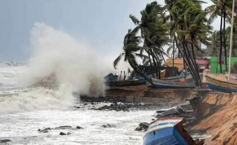
"Wind speeds in Odisha and North Andhra Pradesh will be 70-80 kmph from May 10. Due to adverse water conditions, fishermen are urged not to enter into the sea. The states of Odisha, North Andhra Pradesh, and the west-central Bay of Bengal will be affected "He continued.
According to the top scientist, heavy rain would fall in Jagatsinghpur, Ganjam, and Khordha districts, while light to moderate rain will fall along Odisha's coast.
According to the Odisha government, its disaster response and fire services teams have been set on standby following the forecast.
Cyclones have hit the region in the last three summers: 'Yaas' in 2021, 'Amphan' in 2020, and 'Fani' in 2019.
Odisha Special Relief Commissioner (SRC) PK Jena stated that 17 NDRF (National Disaster Response Force) teams, 20 ODRAF (Odisha Disaster Rapid Action Force) teams, and 175 fire department personnel teams have been requisitioned.
Furthermore, the NDRF authorities have been asked to reserve 10 more teams in case of an emergency.
"Only once the depression forms on May 7 will the IMD be able to provide specifics about the storm, including wind speed and landfall position. Fishermen should avoid going out if the seas are rough starting on May 9. We predict that the cyclonic storm's wind speed in the sea would persist between 80 and 90 kilometres per hour "According to Mohapatra, as quoted by PTI
SK Upadhaya, Director-General of Fire Services, indicated that all leaves for fire service workers had been revoked.
Meanwhile, the energy department and telecom service providers have been directed to begin repair work as soon as possible if their towers are damaged by a possible cyclone.
© Copyright 2020, All Rights Reserved
Powered by Basharat Hosein